Which weather brings people to the hills?
How do rain, gusts, temperature, cloud and the prospect of a view relate to activity? Does that relationship change at weekends, during holidays, between seasons or on different mountains?
Mountain Weather · Public research
The weather changes. So do our plans. Help us understand who heads out, which paths they choose and when they decide to turn back.
We are bringing together hillwalker experiences, historical weather and visitor records, and developing plans for weather instruments and counters on the same hills. The findings will be freely available to the outdoor community.
Part of Spatial Terrain Limited, led by Simon Grogan, founder and lead developer of Mountain Weather.
Why this matters
A quieter summit could mean fewer people started, more chose a lower route, or more turned around. Understanding those differences could make weather guidance more useful and help us interpret mountain-rescue callouts.
How do rain, gusts, temperature, cloud and the prospect of a view relate to activity? Does that relationship change at weekends, during holidays, between seasons or on different mountains?
We want to compare use of exposed ridges, alternative approaches and lower routes with wind strength and direction. Cloud, rain and daylight may also influence where people choose to go.
Counts at successive points, including direction where the instruments support it, could reveal patterns consistent with shorter outings or earlier returns. Voluntary accounts can help explain the decisions behind those patterns.
We want to examine winter walking and other winter activities separately where the records allow. Snow, ice, daylight and lift operation can change both access and participation, so a winter day needs its own context.
A first step · Glen Lyon
We wanted to estimate how large those differences were, beyond seasonal and calendar patterns. We compared 371 screened dates from a four-Munro circuit during parts of 2017 to 2019 with regional ERA5 weather reanalysis. A statistical model allowed for year and month, the day of the week and recorded bank holidays.
| Rain-and-gust category | Recorded activity | Approximate 95% interval |
|---|---|---|
| Excellent | 58% higher | 30% to 92% higher |
| Good | 47% higher | 26% to 73% higher |
| Poor | 35% lower | 14% to 52% lower |
These estimates describe a processed counter-derived activity measure on one circuit. A definition discrepancy in the source material is still being clarified, and three Severe dates were too few for a dependable comparison. The intervals describe statistical uncertainty within this model; they do not capture every source of uncertainty.
What the numbers add: the estimates quantify the difference in recorded activity associated with each weather category, with intervals showing statistical uncertainty. That provides a numerical reference for comparing other routes and seasons, rather than assuming the same relationship everywhere. It is an exploratory behavioural reference for grading, not verification of the complete current hill-weather score. For a separate test against measured weather, see our Cairn Gorm wind and gust development comparison.
The combined result remained similar in the sensitivity checks we ran, but the categories did not form a perfect sequence in every individual year. “Excellent” here means at most 0.2 mm daily precipitation and a maximum model-grid gust of 25 mph; “Good” allows up to 1 mm and 35 mph, excluding Excellent days.
The comparison uses reconstructed conditions and broad historical categories. It cannot tell us which forecast people consulted or establish why any individual went out. It also does not test the complete current hill-day score, the Views score, route choice or rescue risk per outing. Those are questions for further work.
Sources: published Glen Lyon dataset and our forecast-method and participation evidence.
A second setting · Cairngorm Mountain · Updated 7 October 2026
We compared 2025 path-counter records supplied by Cairngorm Mountain with ERA5 historical weather reanalysis. Both the Summit path and the counter supplied as “NCP” recorded more activity in the settled historical categories, after allowing for calendar patterns. Rain and wind also showed clear associations when examined individually.
What we are counting: passages past an instrument, not unique people, summit ascents or passengers on the railway. A person may pass more than once, and the counters must not be added together to estimate visitor numbers. These records cover parts of April to November 2025, not a complete year or winter season.
The category comparison retains 171 complete 24-hour Summit path dates (16,004 passages) and 196 NCP dates (38,123 passages). “Average” below is the named historical rain-and-gust category, not the average of every day. These are model-estimated daily counts, rounded to whole passages, with the calendar mix held constant within each counter.
| Historical category | Summit path | NCP |
|---|---|---|
| Excellent | 135 passages 82% higher (50% to 121% higher) | 260 passages 60% higher (43% to 79% higher) |
| Good | 107 passages 44% higher (18% to 77% higher) | 212 passages 30% higher (12% to 52% higher) |
| Average | 74 passages Reference category | 163 passages Reference category |
| Poor | 26 passages 65% lower (52% to 74% lower) | 82 passages 50% lower (33% to 63% lower) |
| Severe | Estimate unavailable Only one retained date | Estimate unavailable Only one retained date |
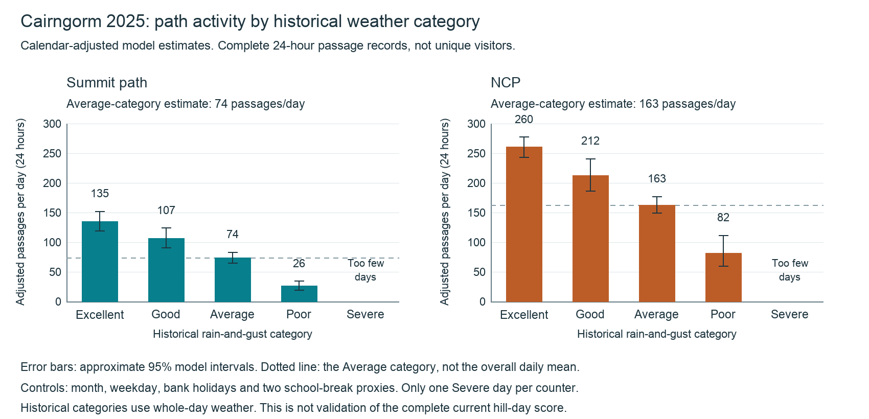
On 4 August 2025, the retained records contain 0 Summit path passages and 2 NCP passages over 24 hours. ERA5 places that date in our historical Severe rain-and-gust category. One date is too little to estimate a typical Severe-day count or a reliable percentage reduction.
This is reconstructed weather, not proof that the forecast available to walkers was rated Severe or displayed zero. We have not replayed archived, issued Mountain Weather scores against these counters. In the current forecast display, scores below zero are shown as Severe hill conditions; exactly zero remains Poor. Glen Lyon also had just three historical Severe dates, too few for a dependable comparison.
The historical rule uses whole-day ERA5 precipitation and maximum model-grid gust, not the complete current hill-day score or Views score. Severe means gusts of at least 60 mph, precipitation of at least 30 mm, or gusts of at least 50 mph with at least 15 mm of precipitation. Otherwise, Poor means gusts of at least 45 mph, at least 15 mm of precipitation, or gusts of at least 38 mph with at least 8 mm of precipitation. Excellent allows at most 0.2 mm and 25 mph; Good allows at most 1 mm and 35 mph, excluding Excellent. Remaining days are Average. These are study categories, not recommended safety limits.
Complete dates by category, Summit path / NCP: Excellent 41 / 51; Good 35 / 43; Average 84 / 91; Poor 10 / 10; Severe 1 / 1. Categories with fewer than ten dates are excluded from the statistical model, not treated as zero activity.
The count model allows for month, day of the week, bank holidays and Highland and Haringey school-break proxies. We predict each category across the same retained calendar dates within each counter, then average those predictions. Uncertainty is clustered by week. A within-week sensitivity comparison gave similar relative differences, but the counters have different retained date mixes and catchments.
Only calendar controls enter this category model, because the category already combines rain and gusts. Snow cover, access, events and other unmeasured influences remain limitations. Statistical intervals do not capture all source, counter or weather-model uncertainty.
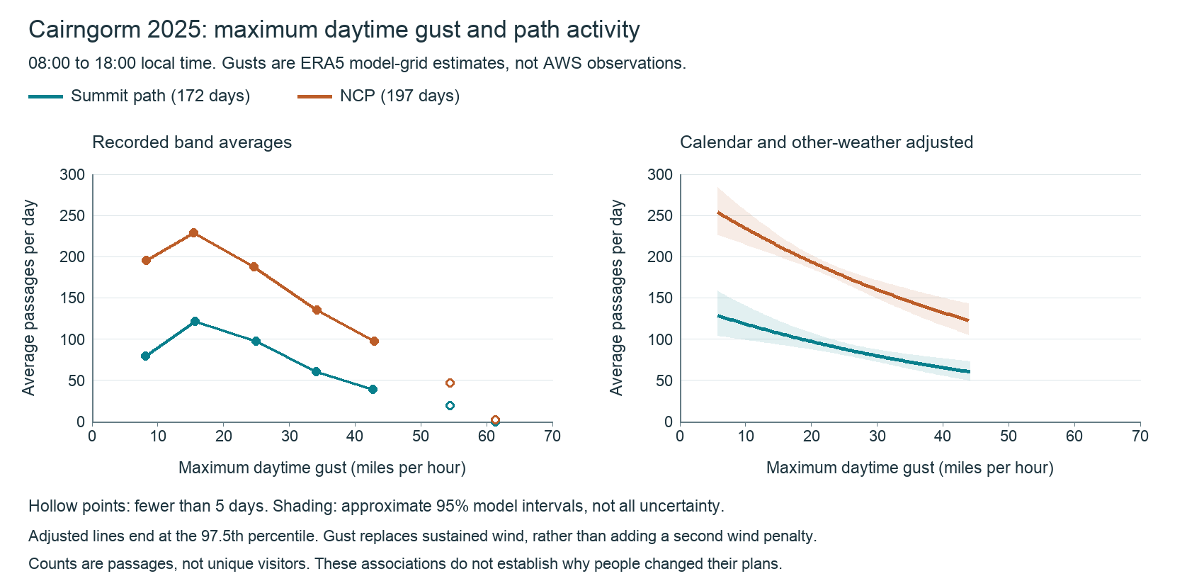
A separate comparison matches complete 08:00 to 18:00 local-time passage records with weather in that window: 172 Summit path dates (15,464 passages) and 197 NCP dates (35,370 passages). Its models allow for the same calendar factors and the other weather variables, rather than treating a wet winter weekday as equivalent to a dry summer weekend.
| Weather difference | Summit path | NCP |
|---|---|---|
| 5 mm more daytime precipitation | 44% fewer (28% to 57% fewer) | 43% fewer (28% to 55% fewer) |
| 10 mph higher maximum hourly sustained wind | 32% fewer (17% to 44% fewer) | 31% fewer (20% to 41% fewer) |
| 10 mph higher maximum daytime gust | 18% fewer (10% to 25% fewer) | 17% fewer (12% to 23% fewer) |
Sustained wind and gust are alternative models, not independent penalties to add together. All wind figures here are ERA5 model-grid estimates, not measured summit winds or winds at walker height. The gust alternative did not clearly improve prediction on held-out weeks. These are exploratory associations within the recorded range, not a universal attendance formula or storm threshold.
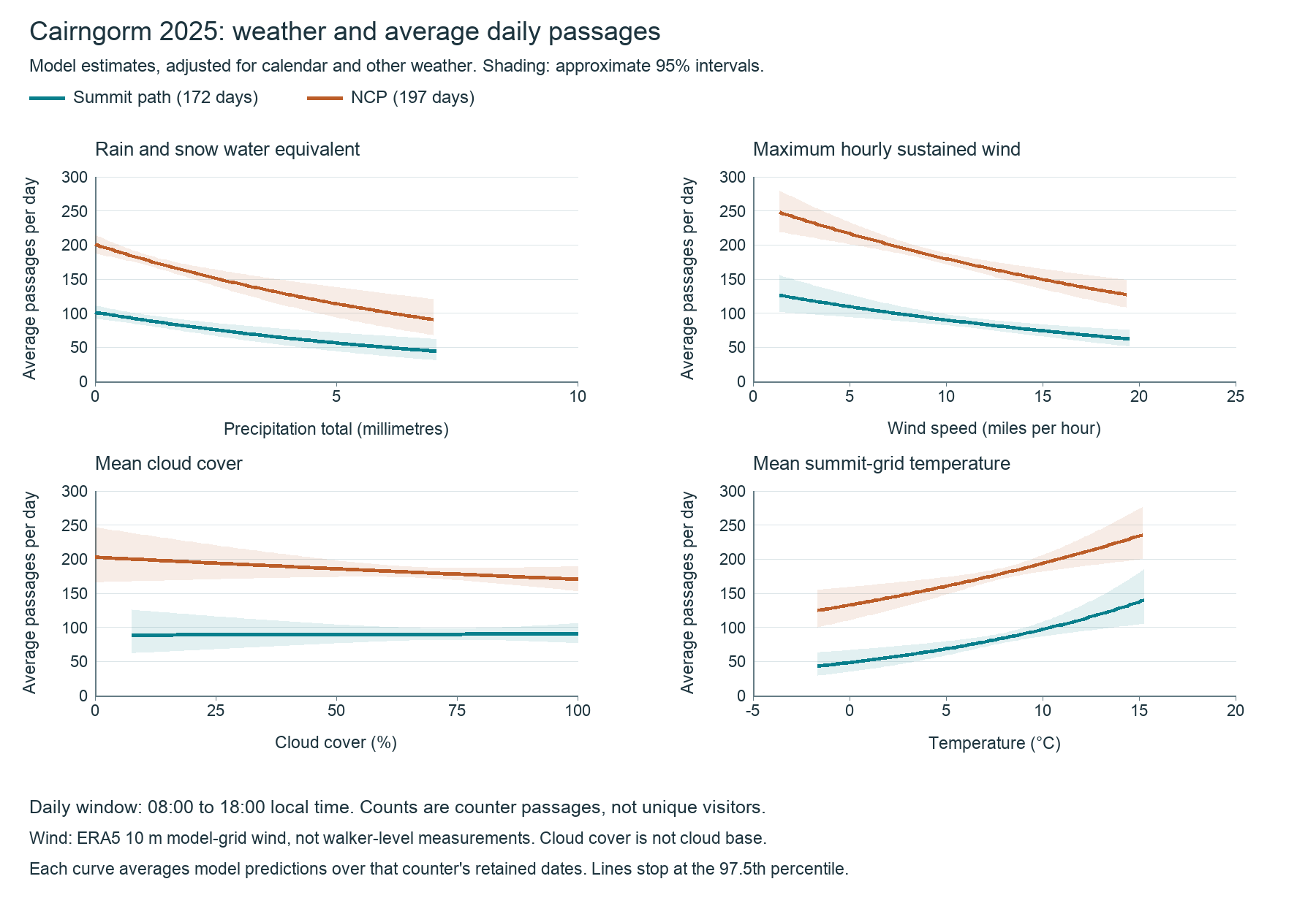
Cloud cover is not cloud base, cloud top or summit visibility, and its association was not clear in this sample. Temperature results depend on the assumed response shape and remain entangled with season, snow and access. We do not yet have a dependable Views-score comparison.
These records cannot establish which forecast a person consulted, whether they changed route or turned back, or whether weather caused a rescue. Fixed-lead archived model forecasts are useful for further comparisons, but are not one frozen public forecast issued before travel decisions. Mountain-rescue risk per outing needs matching incident coverage and an appropriate exposure measure, neither of which these counts alone provide.
The repeated rain-and-wind pattern across Glen Lyon and Cairngorm is worth investigating, but the settings and count measures differ. Further seasons, winter records and paired local weather instruments and counters would help test how transferable the findings are. That is why we are seeking support for the hill monitoring project.
Counter records: supplied by Cairngorm Mountain; only derived aggregate findings are published here. Weather: ERA5 via Open-Meteo historical weather (CC BY 4.0), analysed by Mountain Weather. ERA5 is a reconstruction using observations and a weather model, not a summit instrument record.
The hill monitoring project · Seeking support
Our proposed pilot would combine automatic weather observations with several counters across one mountain's path network. Measuring the approach, alternative branches and upper routes could show how use changes across the hill as the weather changes.
We would like to measure wind, gusts and temperature on exposed high ground, and explore rainfall and other observations where the equipment can provide useful records. Paired exposed and sheltered sites could help test how wind direction changes local conditions.
Historic ERA5 records would provide longer context. Local instruments would help us check what the summit actually experiences and improve the evidence behind terrain adjustments and forecast guidance.
Synchronised counters could compare activity at different elevations and branches through the day. Directional counts may help distinguish outward and returning passages. The aim is aggregate patterns without names, photographs or device tracking.
Counters alone cannot link a person's journey or prove they turned back because of weather. Loops, other exits, repeated passages and missed detections can change the totals. Route mapping, equipment checks and voluntary surveys would help interpret the differences.
A documented instrument layout, checked weather and passage records, and an initial report on how participation varies across the path network. We would publish the methods, coverage, missing data and limitations, with seasonal updates as the record grows.
The project is at the planning stage. No new Mountain Weather summit station is installed yet. The first step is to agree a suitable site, permissions and a costed plan, including installation, power, communications, calibration and maintenance through the seasons.
Help fund, equip or host the pilotGet involved
A first field site needs equipment, local knowledge and people willing to help it keep running. There are also useful ways to contribute before any instrument goes onto a hill.
Help fund a path counter, weather instrument, power supply or communications link. Support for installation, calibration and ongoing maintenance is equally valuable.
We can discuss a contribution towards a pilot or sponsorship of an agreed site, with a clear budget and reporting plan before any commitment.
Discuss funding a pilot →Share a questionnaire link in your shop, newsletter or community channels. Help us reach walkers with different experience levels, including people who changed plans or stayed at home.
You could also sponsor field equipment, offer suitable equipment or technical help, host a research evening, or discuss funding participation rewards for a future survey.
Explore support from your business →Help identify a suitable path network, introduce the people responsible for permissions, or contribute local knowledge about routes and seasonal access. Existing visitor logs could be particularly useful.
Suggest a site or share a data lead →Help with weather sensors, counter design, calibration, power, communications or analysis. We also welcome advice on comparing route use and interpreting incomplete field records.
Offer expertise or equipment →Tell us about your own decisions through the questionnaire, share it with your club, or offer to help pilot future questions. Days when you chose a lower route, turned around or did not go are part of the picture.
Share a hill experience →Contribute a professional perspective →Local volunteers could support agreed equipment checks and maintenance visits once a site is established. Help would be arranged around permissions, training and appropriate conditions.
Register interest in practical help →With their agreement, supporters would be credited in project updates and reports, with their contribution explained. Mountain Weather would retain control of the questions, analysis and publication. Findings would remain freely available, and sponsorship would not give access to individual questionnaire responses.
No participant reward is currently offered. Any future reward scheme would have terms explained before participation and recognise taking part regardless of the answers given.
Talk to Simon about getting involved →An introduction or an idea is welcome. You do not need a complete proposal.