Tell us what you found
A dated photo or a note about cloud, wind or clearance can flag something worth checking. Include the place, time and direction of view, plus the forecast you used if you have it. An ordinary hill day is useful too.
Built for mountain days
Will the wind stop you reaching the ridge? Will the cloud lift before you reach the top? These are the questions Mountain Weather is built around.
We want you to see how the service earns your trust: the measurements, the photographs and the days when the calculations fall short. Walkers, climbers, hill groups and people with a view of the mountains can help us build that record.
In development · Yr Wyddfa / Snowdon
A forecast cloud base is a number. A camera can help us check whether the mountain was actually visible.
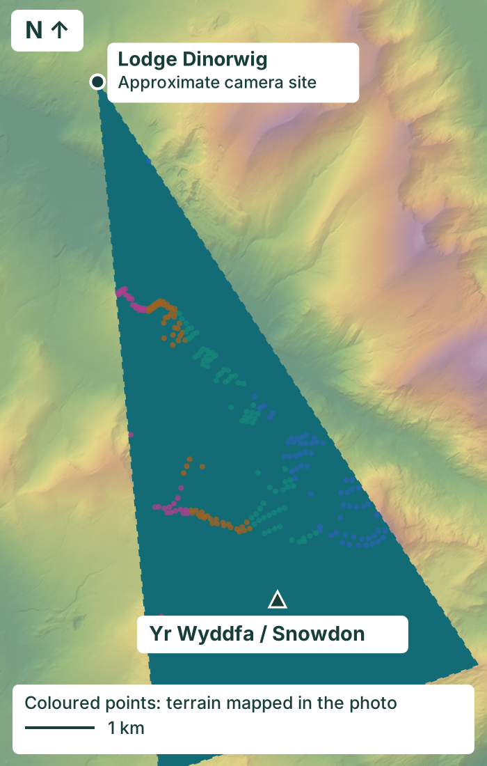
Yr Wyddfa, 8 September 2026 at 07:41 BST. Start with a clear view, add the expected cloud heights, then see what happened. The final view shows how 3D terrain helps us put a height to what we see.
Choose a step to compare the views. Pause the cycle to take a closer look.
A photograph from 19 June 2025 gives us the visible ridges to align with our terrain model. It is a reference from a different day.
Yellow traces show the east and west height estimates on the more distant slopes. Wind is from the west, with lower cloud expected on that side.
The forecast heights broadly agree in parts of the view, but the western forecast trace is lower than several visible contacts. Those differences are what we want to investigate.
Contours at 100 m intervals show approximate terrain heights above sea level, with labelled 400, 600, 800 and 1,000 m levels. The LiDAR reconstruction links image positions to this visible ground. Foreground ridges can hide the mountain behind them, so every point needs a clear line of sight.
A field test you can inspect, not an accuracy score. These are current calculations replayed from inputs saved on 7 September, with hourly guidance interpolated to the photo time. They are not a recovered copy of the original published forecast. We are testing both the flank adjustments and camera alignment. Yellow traces locate the approximate height estimates on the terrain; they are not a predicted cloud outline or an uncertainty band.
Our server saves a frame twice an hour between dawn and dusk, checking its timestamp and skipping duplicates.
We mark where cloud appears to meet terrain and retain uncertain views. These image labels help train Python to propose a line of contact dots for review.
We hold out whole dates when comparing automatic dots with human marks. We also need forecast-blind observations and independent geometry checks before publishing cloud-base accuracy.
Now testing: blue-sky patches and snow. Early image tests are helping us distinguish breaks in the sky from snow on the ground. The next challenge is making that work across different cameras, light and weather. A patch of blue alone cannot tell us the cloud base or prove the summit is clear.
Explore cloud-base observations for Snowdon and Tryfan. View the cameras, step through the terrain and cloud analysis, or download a day's height readings.
The cloudy photograph is from 8 September 2026 at 07:41:07 BST. Forecast inputs were saved on 7 September. Overall hourly cloud-base estimates change from 1,026 m at 07:00 BST to 500 m at 08:00 BST; the displayed calculation assumes a gradual change between them. The exact timing of a cloud change may differ.
The east and west estimates use our provisional windward and sheltered-flank adjustments. They are drawn separately on terrain more than 5 km from the camera, leaving the centre unassigned. The cloud photograph is shifted two image pixels horizontally to align with the reference; no weather content has been altered.
Some development labels were made while forecast guidance was visible. They are useful development labels, but this comparison is not independent forecast validation. The learned detector still produces false cloud dots on the snowy clear-day example, and wisps remain difficult. We have not established a calibrated cloud-height error in metres.
Photographs: Snowdon Webcam Images by DataCymru Ltd, CC BY 4.0. Clear reference · Morning photograph. Original images are unchanged; cropping, alignment and research overlays are added for this presentation.
Terrain contains Welsh Government / Natural Resources Wales LiDAR data under the Open Government Licence v3.0, accessed through DataMapWales. Camera site prior: the map linked from Snowdon Webcam. Example data and provenance.
A camera can suggest a local cloud-contact height where the geometry and view support it. It cannot establish the lowest cloud layer across the whole mountain. Foreground cloud, rain haze, snow and a wet lens can obscure terrain; uncertain heights remain unknown.
Measured at 1,245 metres
We replayed our summit-wind calculation against the Cairn Gorm automatic weather station, using 642 matched sample-hours across 29 dates from 7 July to 5 August 2026.
The calculation followed the rise and fall of summit winds closely. Mean winds differed from the station samples by 4.7 mph on average. Individual errors could be larger, particularly in strong and westerly winds, which were more often underestimated. That gives us a specific problem to work on, then check again on fresh days.
This is a summer development test at station height, before adjusting winds to walker height. It tests the summit calculation, not the accuracy of forecasts issued several days ahead.
| Measurement | Average error | Signed bias | Correlation |
|---|---|---|---|
| Mean wind | 4.7 mph | -0.18 mph | 0.90 |
| Gust | 6.0 mph | +1.17 mph | 0.90 |
Average error is mean absolute error: overestimates and underestimates do not cancel. Bias keeps their sign. Correlation describes how closely winds rise and fall together; it is not percentage accuracy.
Both station samples within an hour must pass quality checks; conflicting duplicates are excluded. These are sampled conditions, not continuous full-hour means or maximum gusts. The dates were used during development, so this is not an independent test or evidence for all UK hills, winter conditions or walker-height accuracy.
Scottish rainfall · Development pilot
For a day in the hills, getting the wet spells right matters as well as getting the total right.
We compared archived rainfall guidance with SEPA gauges at Glen Nevis and Spey Dam. The checks look at how much fell, whether a wet spell was correctly flagged, and when rain began during walking hours. Missed rain and false alarms are counted too.
The pilot also compares the same observations with ERA5, a reconstruction of past weather. That helps us check whether agreement between two models is hiding a difference from what the gauge actually measured.
This is a small summer test of rainfall inputs at two gauge locations, not an accuracy rating for our complete mountain reports.
The study covers 1 July to 29 August 2026. Quality and completeness checks retained 48 dates at Glen Nevis and 41 at Spey Dam for the 10:00 to 16:00 walking period. Those are gauge-date samples, not 89 different calendar days. Provisional or missing readings were excluded from this comparison.
The archived guidance uses fixed lead times before each forecast hour. It is not a replay of one complete Mountain Weather report issued on an earlier day. Comparisons keep the same usable dates across leads; overlapping hours and nearby stations are not treated as independent extra days.
Gauge rainfall does not establish how wet a particular crag became, whether rock dried, or how much snow fell higher up. We use the checks to investigate the rainfall guidance, not to apply a blanket correction to every hill.
Contains SEPA information under the Open Government Licence. SEPA measurements · Archived forecast guidance · About ERA5.
You know the ridge that catches every gust, the corrie that holds the cloud and the moment the tops finally clear. That experience belongs in the conversation about better mountain forecasts.
We are building a service people can use, question and help improve. Come along for the good days, the missed clearances and the discoveries that make the next test better.
You do not need to be a weather expert. Start a conversation with Simon, or add a free forecast to your website.
Show the working. Learn from the misses. We publish selected examples, methods and results so you can follow the work here. Contributions are reviewed before use, with permission agreed before publishing anyone's photographs or data. Informal reports help us find questions; measured, independently checked observations help us answer them.
UK station observations
At Keswick, Aviemore, Capel Curig and Shap, we compared archived GFS guidance with measured weather: 926 dates for wind and temperature, and 780 for rain. These checks test the underlying model, helping us understand its strengths and limits alongside our separate summit-wind work.
Of 619 six-hour periods with at least 1 mm of measured rain, the next-day guidance forecast that much in 402, about 65%. There were 217 misses and 157 false alarms. The amount-band chart below asks a harder question: did it also get the quantity right?
Average wind error grew from 4.4 mph at day 1 to 5.8 mph at day 7. For a trip several days away, keep route options open and check again before committing to exposed ground.
These are lower-ground station checks, not summit measurements. Rain bands describe six-hour amounts: below 1 mm, 1 to below 5 mm, and at least 5 mm.
Here, wet means at least 1 mm in six hours, not any trace of drizzle. Detection counts the observed wet periods forecast as wet. False-alarm share counts the wet forecasts when less than 1 mm fell. These percentages have different denominators and do not add up to 100%. Scroll the table sideways on smaller screens.
| Days ahead | Wet periods detected | Wet periods missed | False-alarm share |
|---|---|---|---|
| Day 1 | 64.9%402 / 619 | 217 / 619 | 28.1%157 / 559 |
| Day 2 | 60.1%372 / 619 | 247 / 619 | 33.0%183 / 555 |
| Day 3 | 52.5%325 / 619 | 294 / 619 | 41.7%232 / 557 |
| Day 4 | 44.9%278 / 619 | 341 / 619 | 50.3%281 / 559 |
For the wetter subset (at least 5 mm), next-day guidance forecast at least 1 mm in 189 of 217 cases. Only 81 reached the observed amount band. That shows underestimated amounts as well as missed rain. These older GFS checks do not establish the rain-detection rate of our complete, current mountain forecasts.
Days ahead · 926 dates, four UK stations
Days ahead · 780 dates, four UK stations, days 1 to 4
Days ahead · 926 dates, four UK stations
Rainfall days 5 to 7 are excluded, not scored as zero. The older GFS archive has a documented processing fault beyond forecast hour 120. Days 1 to 4 lie before that fault. Provider report · Processing fix.
| Days ahead | Mostly dry | Some rain | Wetter |
|---|---|---|---|
| Day 1 | 92.3%1885 / 2042 | 45.0%181 / 402 | 37.3%81 / 217 |
| Day 2 | 91.0%1859 / 2042 | 38.8%156 / 402 | 31.8%69 / 217 |
| Day 3 | 88.6%1810 / 2042 | 32.3%130 / 402 | 28.1%61 / 217 |
| Day 4 | 86.2%1761 / 2042 | 29.4%118 / 402 | 24.0%52 / 217 |
Each percentage is the share of an observed rain band forecast in that same band. It is not the probability that a future forecast will be right. Dry periods dominate the sample, so an overall match rate would hide wet-weather misses.
| Days ahead | Mean wind, mph | Temperature, °C |
|---|---|---|
| Day 1 | 4.404.20 to 4.61 | 1.251.21 to 1.30 |
| Day 2 | 4.574.35 to 4.79 | 1.391.33 to 1.45 |
| Day 3 | 4.724.51 to 4.94 | 1.511.44 to 1.58 |
| Day 4 | 4.994.76 to 5.23 | 1.721.64 to 1.79 |
| Day 5 | 5.315.05 to 5.59 | 1.881.80 to 1.97 |
| Day 6 | 5.585.33 to 5.83 | 2.162.04 to 2.28 |
| Day 7 | 5.815.55 to 6.08 | 2.382.26 to 2.50 |
Wind and temperature use reports at 12:00 UTC; rain uses the six-hour total ending then. Missing rain is not zero. Matching and quality checks retain 2,661 rainfall station-periods at each of the four leads, from January 2024 to March 2026. Wind and temperature extend to August 2026.
The GFS fixed-lead archive is underlying guidance, not a reconstruction of our published reports. Nearby stations and dates are correlated. Wind and temperature intervals use 2,000 calendar-week resamples. The download retains quality-flag sensitivity checks and seasonal-reference comparisons; rainfall percentages have no calculated sampling intervals.
Rain counts and matrices · Full UK study and methods (rain days 5 to 7 excluded) · NOAA GHCN station observations · Forecast archive
Check summit wind, cloud and rain timing. Use the confidence explanation to see what could change.
Look for improving or deteriorating conditions, then revisit the timing as your trip approaches.
Use the broader outlook to spot opportunities, rather than choosing a summit hour this far ahead.
Our next verification step is to score complete, saved Mountain Weather forecasts against observations at each lead time. That will test the forecasts people received, as well as the calculations behind them.
This smaller study gives additional context at longer leads. Its climate, dates and daytime measurement window differ from the UK comparison, so the results are kept separate.
Payerne, Zürich/Kloten and Bern/Zollikofen provide 60 May/August dates for wind and temperature. Rain uses 30 August dates from runs issued after the July processing fix: 81 mostly dry, 3 some-rain and 6 wetter periods. Those small wet-weather counts make the percentages sensitive to individual events.
Days ahead · 60 Swiss dates, three lowland stations
Days ahead · 30 August dates, three Swiss lowland stations
| Days ahead | Mostly dry | Some rain | Wetter |
|---|---|---|---|
| Day 1 | 98.8%80 / 81 | 33.3%1 / 3 | 50.0%3 / 6 |
| Day 2 | 100.0%81 / 81 | 66.7%2 / 3 | 33.3%2 / 6 |
| Day 3 | 97.5%79 / 81 | 33.3%1 / 3 | 66.7%4 / 6 |
| Day 4 | 97.5%79 / 81 | 66.7%2 / 3 | 16.7%1 / 6 |
| Day 5 | 92.6%75 / 81 | 33.3%1 / 3 | 16.7%1 / 6 |
| Day 6 | 95.1%77 / 81 | 33.3%1 / 3 | 16.7%1 / 6 |
| Day 7 | 95.1%77 / 81 | 33.3%1 / 3 | 33.3%2 / 6 |
| Day 8 | 82.7%67 / 81 | 33.3%1 / 3 | 33.3%2 / 6 |
| Day 9 | 85.2%69 / 81 | 0.0%0 / 3 | 0.0%0 / 6 |
| Day 10 | 88.9%72 / 81 | 0.0%0 / 3 | 0.0%0 / 6 |
| Day 11 | 79.0%64 / 81 | 0.0%0 / 3 | 0.0%0 / 6 |
| Day 12 | 91.4%74 / 81 | 0.0%0 / 3 | 0.0%0 / 6 |
| Day 13 | 84.0%68 / 81 | 0.0%0 / 3 | 0.0%0 / 6 |
| Day 14 | 80.2%65 / 81 | 0.0%0 / 3 | 0.0%0 / 6 |
GFS 00:00 UTC single runs are compared with measured 10:00 to 16:00 Europe/Zurich conditions. Rain uses runs from 18 July 2026 onwards. Wind and temperature intervals use 500 calendar-week resamples. This is underlying-model research, not validation of UK mountain forecasts.
Rain counts and methods · Wind and temperature results (mixed-period rainfall superseded) · MeteoSwiss observations · Forecast archive